Mukriyan
36°45′47″N 45°43′20″E / 36.76306°N 45.72222°E / 36.76306; 45.72222
| Mukri Emirateموکریان | |||||||||
|---|---|---|---|---|---|---|---|---|---|
| c. 1400–c. 1800 | |||||||||
 | |||||||||
| Capital | Mahabad | ||||||||
| Common languages | Sorani Kurdish | ||||||||
| Religion | Shafiʽi Sunni Islam | ||||||||
| Government | Monarchy | ||||||||
| History | |||||||||
| • Established | c. 1400 | ||||||||
| • Dissolved | c. 1800 | ||||||||
| |||||||||
Mukriyan (Kurdish: موکریان) or 'Deryaz' was a Kurdish principality from the late 14th century to the 19th century centered around Mahabad. Mukriyan was a neighbor to the Emirate of Bradost.
Geography and tribes
 Kurdish noblewoman Aryana Xanum from Mukriyan by unknown Tableau weaver; circa 16th century
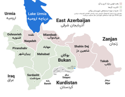
Mukriyan encompassed the area south of Lake Urmia, including the cities of Mahabad, Bukan, Sardasht and Oshnaviyeh with the city of Naqadeh historically being included in Mukriyan, though today Kurds only make up approximately 35% of the city. The city of Saqqez is culturally very similar to Mukriyan, though politically it acted more as its own city-state under the Principality of Ardalan, though as an autonomous vassal and not a part of Ardalani central control.
A few tribes include Dehbruki, Gewirk, Mangur, Mukri, Amireh, Khelki, Sheikh Sherefi, Selekei, Ḥasan Khāli, Kārish, Silki, Sekir, Fekiyesi, Ables, Bārik, Soleimāni, Beyi, Omerbil, Merzink, Lētāu Māwet, and Shiwezāi.
History
Before Mukris, the region was ruled by Hadhabanis, the region is also in the same, or similar, location as Mannea and Takht-e Soleymān. During the battle of Dimdim, Mukriyanis rallied around Kurds of Bradost. Abbas I of Persia married a Mukri noblewomen in 1610 AD following the execution of her brother, Bodagh Soltan, during the defeat of the Mukri at the battle of Dimdim.
See also
References
- ^ Meiselas, Susan (1997). Kurdistan. Random House. ISBN 9780679423898.
- ^ Hassanpour, Amir (1989). "BŪKĀN". Encyclopedia Iranica. IV.
- ^ Rosskeen Gibb, Hamilton Alexander (1954). The Encyclopaedia of Islam (Volume 4 ed.). Brill. pp. 188–192.
- ^ Eagleton, William (1963). The Kurdish Republic of 1946. The University of Michigan: Oxford University Press. pp. 26–27.
- ^ Hassanpour, Amir (1989). "BŪKĀN". Encyclopedia Iranica. IV.
- ^ Hassanpour, Amir (1988). "BARĀDŪST". Encyclopedia Iranica. III.
- ^ "Obesity consequences from the people's perspective living in Kurdish regions of Iran: A qualitative content analysis". August 2019. doi:10.4103/jehp.jehp_13_19 (inactive 31 January 2024).{{cite web}}: CS1 maint: DOI inactive as of January 2024 (link)
- ^ Minorsky.
- ^ Franz, Erhard (1981). Minderheiten in Iran: Dokumentation zur Ethnographie und Politik. Deutsches Orient-Institut, Dokumentations-Leitstelle Moderner Orient. p. 39. ISBN 9783886930081.
- ^ "Saqqez - Language distribution: Kordestan Province". Iran Atlas. Retrieved 13 May 2021.
- ^ Ateş, Sabri (2013). Ottoman-Iranian Borderlands. United Kingdom of Great Britain and Northern Ireland: Cambridge University Press. p. 36. ISBN 9781107033658.
- ^ Minorsky, Vladimir (1957). "Mongol Place-Names in Mukri Kurdistan (Mongolica, 4)". Cambridge University Press. 19 (1): 68 & 73. JSTOR 609632 – via JSTOR.
- ^ Rawlinson, Henry. Mukriyans. p. 34.
- ^ DIMDIM Archived April 25, 2006, at the Wayback Machine
- ^ Butler, Herbert (2012). Sir Thomas Herbert, Bart: Travels in Africa, Persia, and Asia the Great : Some Years Travels Into Africa and Asia the Great, Especially Describing the Famous Empires of Persia and Hindustan, as Also Divers Other Kingdoms in the Oriental Indies, 1627-30, the 1677 Version. Medieval & Renaissance Texts & Studies. ACMRS (Arizona Center for Medieval and Renaissance Studies). p. 403. ISBN 978-0-86698-475-1.
- ^ American Society of Genealogists. 1997. p. 244.
Sources
- Minorsky, "Suldūz", Encyclopedia of Islam, Second Edition, doi:10.1163/1573-3912_islam_SIM_7169
Further reading
- Hassanpour, Amir (1980). Notes on social structure of Mukriyan, the history of mullas in Mukriyan genealogy of land lords, material in Persian and English.
This Kurdistan-related article is a stub. You can help Wikipedia by expanding it. |
This Iranian history-related article is a stub. You can help Wikipedia by expanding it. |