Avroult
In this article, the topic of Avroult will be addressed from different perspectives, with the purpose of exploring its implications, applications and relevance today. Its historical context, its possible impacts in various areas and its relevance in the current panorama will be analyzed in detail. Likewise, its possible future implications will be delved into and various points of view on Avroult will be discussed. Through a journey through different approaches and opinions, the aim is to provide the reader with a comprehensive and detailed vision of this topic, with the aim of encouraging debate and reflection.
Avroult | |
|---|---|
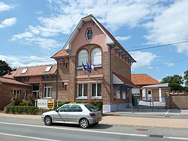
 The town hall of Avroult | |
| Coordinates: 50°38′02″N 2°08′53″E / 50.6339°N 2.1481°E | |
| Country | France |
| Region | Hauts-de-France |
| Department | Pas-de-Calais |
| Arrondissement | Saint-Omer |
| Canton | Fruges |
| Intercommunality | CA Pays de Saint-Omer |
| Government | |
| • Mayor (2020–2026) | Isabelle Lemaire[1] |
Area 1 | 4.78 km2 (1.85 sq mi) |
| Population (2022)[2] | 541 |
| • Density | 110/km2 (290/sq mi) |
| Time zone | UTC+01:00 (CET) |
| • Summer (DST) | UTC+02:00 (CEST) |
| INSEE/Postal code | 62067 /62560 |
| Elevation | 104–161 m (341–528 ft) (avg. 141 m or 463 ft) |
| 1 French Land Register data, which excludes lakes, ponds, glaciers > 1 km2 (0.386 sq mi or 247 acres) and river estuaries. | |
Avroult (West Flemish: Averhout) is a commune in the Pas-de-Calais department in northern France.[3]
Geography
A village located 10 miles (16 km) southwest of Saint-Omer, at the junction of the D928 with the D133 road.
Population
| Year | Pop. | ±% p.a. |
|---|---|---|
| 1968 | 286 | — |
| 1975 | 282 | −0.20% |
| 1982 | 327 | +2.14% |
| 1990 | 416 | +3.05% |
| 1999 | 510 | +2.29% |
| 2009 | 539 | +0.55% |
| 2014 | 593 | +1.93% |
| 2020 | 593 | +0.00% |
| Source: INSEE[4] | ||
Sights
- The sixteenth century church of St. Omer.
See also
References
- ^ "Répertoire national des élus: les maires". data.gouv.fr, Plateforme ouverte des données publiques françaises (in French). 2 December 2020.
- ^ "Populations de référence 2022" (in French). The National Institute of Statistics and Economic Studies. 19 December 2024.
- ^ INSEE commune file
- ^ Population en historique depuis 1968, INSEE


