|
|
Name on the Register
|
Image
|
Date listed
|
Location
| City or town |
Description
|
| 1
|
Apalachicola Fort
|
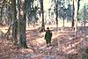 Apalachicola Fort Apalachicola Fort
|
October 15, 1966
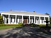
(#66000931)
|
Address Restricted
| Holy Trinity |
|
| 2
|
Bass–Perry House
|
 Bass–Perry House Bass–Perry House
|
January 19, 1976
(#76000355)
|
4 miles northeast of Seale on U.S. Route 431
32°20′45″N 85°07′55″W / 32.34593°N 85.13197°W / 32.34593; -85.13197 (Bass–Perry House)
| Seale |
|
| 3
|
Brooks–Hughes House
|
 Brooks–Hughes House Brooks–Hughes House
|
November 3, 1983
(#83003477)
|
1010 Sandfort Rd.
32°27′34″N 85°00′29″W / 32.45935°N 85.00797°W / 32.45935; -85.00797 (Brooks–Hughes House)
| Phenix City |
|
| 4
|
Brownville–Summerville Historic District
|
|
November 3, 1983
(#83003479)
|
Roughly bounded by 15th and 23rd Sts. and 6th and 11th Aves.
32°28′40″N 85°00′17″W / 32.477778°N 85.004722°W / 32.477778; -85.004722 (Brownville–Summerville Historic District)
| Phenix City |
|
| 5
|
Floyd–Newsome House
|
 Floyd–Newsome House Floyd–Newsome House
|
November 3, 1983
(#83004373)
|
900 22nd St.
32°28′56″N 85°00′15″W / 32.48223°N 85.00411°W / 32.48223; -85.00411 (Floyd–Newsome House)
| Phenix City |
|
| 6
|
Fort Mitchell Site
|
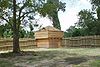 Fort Mitchell Site Fort Mitchell Site
|
June 13, 1972
(#72000178)
|
Address Restricted
| Fort Mitchell |
|
| 7
|
Fort No. 5
|
 Fort No. 5 Fort No. 5
|
May 6, 1976
(#76000354)
|
West of Phenix on the Opelika Highway
32°29′00″N 85°02′04″W / 32.48342°N 85.03445°W / 32.48342; -85.03445 (Fort No. 5)
| Phenix City |
|
| 8
|
Girard High School
|
|
November 3, 1983
(#83003480)
|
Sandfort Rd.
32°27′39″N 85°00′15″W / 32.46073°N 85.00405°W / 32.46073; -85.00405 (Girard High School)
| Phenix City |
Girard High School building was demolished in 1994.
|
| 9
|
Girard Historic District
|
|
November 3, 1983
(#83003481)
|
Roughly bounded by 8th Pl., 10th St., 5th and 8th Aves.
32°27′45″N 85°00′06″W / 32.4625°N 85.001667°W / 32.4625; -85.001667 (Girard Historic District)
| Phenix City |
|
| 10
|
Glenn–Thompson Plantation
|
 Glenn–Thompson Plantation Glenn–Thompson Plantation
|
April 9, 1980
(#80000735)
|
South of Pittsview on U.S. Route 431
32°08′14″N 85°09′03″W / 32.13726°N 85.15078°W / 32.13726; -85.15078 (Glenn–Thompson Plantation)
| Pittsview |
|
| 11
|
Glennville Historic District
|
 Glennville Historic District Glennville Historic District
|
August 7, 1979
(#79000402)
|
South of Pittsview
32°06′38″N 85°10′09″W / 32.110556°N 85.169167°W / 32.110556; -85.169167 (Glennville Historic District)
| Pittsview |
|
| 12
|
Joel Hurt House
|
 Joel Hurt House Joel Hurt House
|
August 11, 2005
(#05000834)
|
605 Church St.
32°14′26″N 85°24′39″W / 32.24046°N 85.41092°W / 32.24046; -85.41092 (Joel Hurt House)
| Hurtsboro |
|
| 13
|
Hurtsboro Historic District
|
 Hurtsboro Historic District Hurtsboro Historic District
|
October 19, 2009
(#09000001)
|
308-905 Church St., 508 Daniel St., 303-407 Dickinson St., 302-802 Goolsby St., 402-502 Lloyd St., and 242-282 Long St.
32°14′40″N 85°24′47″W / 32.244475°N 85.413117°W / 32.244475; -85.413117 (Hurtsboro Historic District)
| Hurtsboro |
|
| 14
|
Kid Alley Residential Historic District
|
|
November 3, 1983
(#83003482)
|
11th Ave. at 9th Pl.
32°27′52″N 85°00′27″W / 32.464444°N 85.0075°W / 32.464444; -85.0075 (Kid Alley Residential Historic District)
| Phenix City |
|
| 15
|
Lower Twentieth Street Residential Historic District
|
|
November 3, 1983
(#83003483)
|
20th St. from 2nd to 6th Aves.
32°28′47″N 84°59′55″W / 32.479722°N 84.998611°W / 32.479722; -84.998611 (Lower Twentieth Street Residential Historic District)
| Phenix City |
|
| 16
|
Morgan–Curtis House
|
 Morgan–Curtis House Morgan–Curtis House
|
November 3, 1983
(#83003484)
|
1815 Abbott Dr.
32°28′03″N 85°01′11″W / 32.46754°N 85.01965°W / 32.46754; -85.01965 (Morgan–Curtis House)
| Phenix City |
|
| 17
|
Phenix City Post Office Building
|
 Phenix City Post Office Building Phenix City Post Office Building
|
November 30, 2021
(#100007192)
|
500 14th St.
32°28′23″N 85°00′00″W / 32.4730°N 85.0°W / 32.4730; -85.0 (Phenix City Post Office Building)
| Phenix City |
Contains the mural Cotton by John Kelly Fitzpatrick
|
| 18
|
Samuel R. Pitts Plantation
|
 Samuel R. Pitts Plantation Samuel R. Pitts Plantation
|
June 25, 1992
(#92000819)
|
East of U.S. Route 431, south of the Southern railroad tracks
32°10′48″N 85°09′42″W / 32.18006°N 85.16177°W / 32.18006; -85.16177 (Samuel R. Pitts Plantation)
| Pittsview |
|
| 19
|
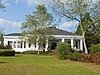
Russell County Courthouse at Seale
|
 Russell County Courthouse at Seale Russell County Courthouse at Seale
|
May 23, 1974
(#74000436)
|
Courthouse Sq.
32°17′54″N 85°10′03″W / 32.29831°N 85.16738°W / 32.29831; -85.16738 (Russell County Courthouse at Seale)
| Seale |
|
| 20
|
Shapre–Monte House
|
 Shapre–Monte House Shapre–Monte House
|
November 3, 1983
(#83003485)
|
721 6th Ave.
32°27′33″N 85°00′06″W / 32.45915°N 85.0017°W / 32.45915; -85.0017 (Shapre–Monte House)
| Phenix City |
|
| 21
|
Smith Residential Historic District
|
|
November 3, 1983
(#83003486)
|
20th St., 7th Ave., and 6th Court
32°28′47″N 85°00′04″W / 32.479722°N 85.001111°W / 32.479722; -85.001111 (Smith Residential Historic District)
| Phenix City |
|
| 22
|
Snow Valley Residential Historic District
|
|
November 3, 1983
(#83003487)
|
11th and 12th Sts. at 11th Ave.
32°28′04″N 85°00′29″W / 32.467778°N 85.008056°W / 32.467778; -85.008056 (Snow Valley Residential Historic District)
| Phenix City |
|
| 23
|
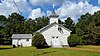
Uchee Methodist Church
|
 Uchee Methodist Church Uchee Methodist Church
|
July 3, 1997
(#97000654)
|
County Road 22, 1.8 miles west of its junction with County Road 65
32°21′12″N 85°19′53″W / 32.35344°N 85.3313°W / 32.35344; -85.3313 (Uchee Methodist Church)
| Uchee |
|
| 24
|
Upper Twentieth Street Residential Historic District
|
|
November 3, 1983
(#83003488)
|
1201-1217 W. 20th St.
32°28′45″N 85°00′38″W / 32.479167°N 85.010556°W / 32.479167; -85.010556 (Upper Twentieth Street Residential Historic District)
| Phenix City |
|
| 25
|
Yuchi Town
|
 Yuchi Town Yuchi Town
|
June 19, 1996
(#95000453)
|
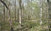
Address Restricted
| Fort Benning |
|
 Location of Russell County in Alabama


.jpg)


 Map of Alabama highlighting Russell County