Markenbinnen
In this article, we will explore Markenbinnen from different perspectives and in various contexts. Markenbinnen is a topic that has sparked interest and debate over time, and its relevance continues to be evident today. Through this article, we will delve into the multiple aspects that Markenbinnen encompasses, addressing its implications, its history, its impact on today's society, as well as the possible perspectives offered by experts and scholars on the subject. Likewise, we will examine different opinions and points of view in relation to Markenbinnen, with the purpose of providing the reader with a complete and enriching vision on this topic.
Markenbinnen | |
|---|---|
Village | |
 Dutch Reformed church of Markenbinnen | |
 Markenbinnen Location in the Netherlands  Markenbinnen Location in the province of North Holland in the Netherlands | |
| Coordinates: 52°32′N 4°47′E / 52.533°N 4.783°E | |
| Country | Netherlands |
| Province | North Holland |
| Municipality | Alkmaar |
| Area | |
• Total | 1.46 km2 (0.56 sq mi) |
| Elevation | −0.8 m (−2.6 ft) |
| Population (2021)[1] | |
• Total | 325 |
| • Density | 220/km2 (580/sq mi) |
| Time zone | UTC+1 (CET) |
| • Summer (DST) | UTC+2 (CEST) |
| Postal code | 1536[1] |
| Dialing code | 075 |
Markenbinnen is a village in the Dutch province of North Holland. It is a part of the municipality of Alkmaar, and lies about 10 km north of Zaandam.
The village was first mentioned in 1395 or 1396 as Marken, and means "border line". It was earlier located on a little island. "Binnen" (inside) has been added to distinguish from Marken.[3] Markenbinnen developed in the Late Middle Ages as a peat excavation settlement. Around 1644, the Markervaart was dug separating the Markerpolder from the Oostwouderpolder.[4]
The Dutch Reformed church is an aisleless church with wooden tower built 1704 as a replacement for its medieval predecessor.[4] Markenbinnen was home to 183 people in 1840.[5]
The Fort Marken-Binnen was constructed as part of the Stelling van Amsterdam and was completed in 1905. It was used during World War I and II as barracks, but became military obsolete after the World War II.[6]
Gallery
-
 Village street in winter
 -
 Fort Marken-Binnen
 -
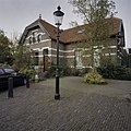 Teacher's house

.jpg)

References
- ^ a b c "Kerncijfers wijken en buurten 2021". Central Bureau of Statistics. Retrieved 28 April 2022.
- ^ "Postcodetool for 1536AB". Actueel Hoogtebestand Nederland (in Dutch). Het Waterschapshuis. Retrieved 28 April 2022.
- ^ "Markenbinnen - (geografische naam)". Etymologiebank (in Dutch). Retrieved 28 April 2022.
- ^ a b Ronald Stenvert & Saskia van Ginkel-Meester (2006). "Markenbinnen" (in Dutch). Zwolle: Waanders. Retrieved 28 April 2022.
- ^ "Markenbinnen". Plaatsengids (in Dutch). Retrieved 28 April 2022.
- ^ "Fort Marken-Binnen". Forten (in Dutch). Retrieved 28 April 2022.
| Authority control databases: National |
|---|
This North Holland location article is a stub. You can help Wikipedia by expanding it. |