La Rochepot
In this article we will be addressing La Rochepot, a topic that has captured the attention of numerous individuals around the world. In order to provide a comprehensive and detailed view on La Rochepot, we will explore different aspects related to this topic, from its origins to its relevance today. Additionally, we will examine various perspectives and opinions of experts in the field, with the purpose of offering readers a deep and complete understanding of La Rochepot. In addition, we will analyze the impact that La Rochepot has had in different areas, as well as its possible implications for the future. Ultimately, this article aims to shed light on La Rochepot, providing readers with an informed and enriching perspective on this topic.
You can help expand this article with text translated from the corresponding article in French. (January 2009) Click for important translation instructions.
|
La Rochepot | |
|---|---|
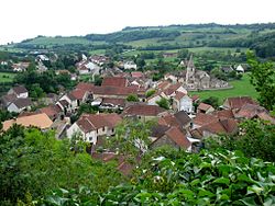
 A general view of La Rochepot | |
.svg) Coat of arms | |
Location of La Rochepot  | |
 La Rochepot  La Rochepot | |
| Coordinates: 46°57′32″N 4°40′47″E / 46.9589°N 4.6797°E | |
| Country | France |
| Region | Bourgogne-Franche-Comté |
| Department | Côte-d'Or |
| Arrondissement | Beaune |
| Canton | Arnay-le-Duc |
| Intercommunality | CA Beaune Côte et Sud |
| Government | |
| • Mayor (2020–2026) | Véronique Richer[1] |
Area 1 | 13.91 km2 (5.37 sq mi) |
| Population (2022)[2] | 281 |
| • Density | 20/km2 (52/sq mi) |
| Time zone | UTC+01:00 (CET) |
| • Summer (DST) | UTC+02:00 (CEST) |
| INSEE/Postal code | 21527 /21340 |
| Elevation | 324–561 m (1,063–1,841 ft) |
| 1 French Land Register data, which excludes lakes, ponds, glaciers > 1 km2 (0.386 sq mi or 247 acres) and river estuaries. | |
La Rochepot (French pronunciation: [la ʁɔʃpo]) is a commune in France in Bourgogne-Franche-Comté, Côte-d'Or department. It is a part of the canton of Arnay-le-Duc and of the arrondissement of Beaune. It has a hillside castle, converted to a château, on the D973 road between Beaune and Nolay on the way to Saisy.
The INSEE code is 21527.
History
La Rochepot is known for its castle, the Château de la Rochepot. The earliest record of the castle dates back to 1180 when it was called "Château de La Roche Nolay". In 1403, the castle was bought by Regnier Pot, a knight, who renamed it.
The commune of La Rochepot is famous for its winemaking traditions. The primary cultivated grape varieties are Pinot Noir and Chardonnay.[3]
-
 La Rochepot
 -
 The château
 -
 The château
 -
 The château roof
 -
 The château
 -
 The château
 -
 Vines
Vines


Geography
Climate
La Rochepot has an oceanic climate (Köppen climate classification Cfb). The average annual temperature in La Rochepot is 10.2 °C (50.4 °F). The average annual rainfall is 837.3 mm (32.96 in) with May as the wettest month. The temperatures are highest on average in July, at around 19.3 °C (66.7 °F), and lowest in January, at around 1.6 °C (34.9 °F). The highest temperature ever recorded in La Rochepot was 39.0 °C (102.2 °F) on 12 August 2003; the coldest temperature ever recorded was −21.0 °C (−5.8 °F) on 9 January 1985.
| Climate data for La Rochepot (1981–2010 averages, extremes 1949−present) | |||||||||||||
|---|---|---|---|---|---|---|---|---|---|---|---|---|---|
| Month | Jan | Feb | Mar | Apr | May | Jun | Jul | Aug | Sep | Oct | Nov | Dec | Year |
| Record high °C (°F) | 14.5 (58.1) |
20.4 (68.7) |
23.8 (74.8) |
28.5 (83.3) |
32.0 (89.6) |
36.2 (97.2) |
38.0 (100.4) |
39.0 (102.2) |
34.0 (93.2) |
28.5 (83.3) |
21.1 (70.0) |
17.5 (63.5) |
39.0 (102.2) |
| Mean daily maximum °C (°F) | 4.4 (39.9) |
6.2 (43.2) |
10.8 (51.4) |
14.4 (57.9) |
18.9 (66.0) |
22.5 (72.5) |
25.2 (77.4) |
24.6 (76.3) |
20.1 (68.2) |
14.8 (58.6) |
8.5 (47.3) |
5.1 (41.2) |
14.7 (58.5) |
| Daily mean °C (°F) | 1.6 (34.9) |
2.6 (36.7) |
6.3 (43.3) |
9.2 (48.6) |
13.5 (56.3) |
16.8 (62.2) |
19.3 (66.7) |
18.8 (65.8) |
14.9 (58.8) |
10.7 (51.3) |
5.3 (41.5) |
2.4 (36.3) |
10.2 (50.4) |
| Mean daily minimum °C (°F) | −1.3 (29.7) |
−1.0 (30.2) |
1.7 (35.1) |
4.0 (39.2) |
8.2 (46.8) |
11.2 (52.2) |
13.3 (55.9) |
13.0 (55.4) |
9.7 (49.5) |
6.6 (43.9) |
2.1 (35.8) |
−0.3 (31.5) |
5.6 (42.1) |
| Record low °C (°F) | −21.0 (−5.8) |
−20.0 (−4.0) |
−14.5 (5.9) |
−5.5 (22.1) |
−3.0 (26.6) |
1.5 (34.7) |
4.0 (39.2) |
0.0 (32.0) |
0.0 (32.0) |
−6.0 (21.2) |
−11.0 (12.2) |
−18.0 (−0.4) |
−21.0 (−5.8) |
| Average precipitation mm (inches) | 67.6 (2.66) |
56.2 (2.21) |
55.1 (2.17) |
68.2 (2.69) |
82.9 (3.26) |
72.5 (2.85) |
65.9 (2.59) |
59.6 (2.35) |
71.3 (2.81) |
81.3 (3.20) |
81.9 (3.22) |
74.8 (2.94) |
837.3 (32.96) |
| Average precipitation days (≥ 1.0 mm) | 11.9 | 10.5 | 10.4 | 10.6 | 11.5 | 8.7 | 7.4 | 8.3 | 8.4 | 11.0 | 12.1 | 12.2 | 123.1 |
| Source: Meteociel[4] | |||||||||||||
Population
| Year | Pop. | ±% p.a. |
|---|---|---|
| 1968 | 275 | — |
| 1975 | 258 | −0.91% |
| 1982 | 272 | +0.76% |
| 1990 | 241 | −1.50% |
| 1999 | 260 | +0.85% |
| 2007 | 281 | +0.98% |
| 2012 | 289 | +0.56% |
| 2017 | 291 | +0.14% |
| Source: INSEE[5] | ||
Economy
In 2010, of 171 persons of working age (15–64 years old), 120 were regarded as economically active; the economic activity rate was 70,2% compared to 71.9% in 1999. Of the 120 active persons, 115 persons (65 men and 50 women) had a job, five were jobless (3 men and 2 women). Of the 51 economically inactive persons, 14 persons were schoolchildren and students, 24 were retired and 13 were inactive for other reasons.[6]
See also
References
- ^ "Répertoire national des élus: les maires" (in French). data.gouv.fr, Plateforme ouverte des données publiques françaises. 13 September 2022.
- ^ "Populations de référence 2022" (in French). The National Institute of Statistics and Economic Studies. 19 December 2024.
- ^ Thorsten Droste (1998). Burgund: Klšster, Schlšsser, historische StŠdte und die Kultur des Weinbaus im Herzen Frankreichs (in German). DuMont Reiseverlag, 1998. ISBN 9783770141661.
- ^ "Normales et records pour La Rochepot (21)". Meteociel. Retrieved 18 June 2022.
- ^ Population en historique depuis 1968, INSEE
- ^ "Base chiffres clés: emploi — population active 2010" (in French). INSEE. Retrieved 29 August 2014. (crude data, in 1999 temporary employment was partially registered)
External links
- Website of Château de la Rochepot
- An article on Château de la Rochepot Archived 2010-05-13 at the Wayback Machine
| Metropolitan regions |
|
|---|---|
| Overseas regions | |
| Île-de-France |
| |
|---|---|---|
| Parisian basin |
| |
| Nord-Pas-de-Calais | ||
| East |
| |
| West | ||
| South West | ||
| Centre East | ||
| Mediterranean | ||
| Multiple regions |
| |
| Overseas departments and territories | ||
| ||
| International | |
|---|---|
| National | |
This Arrondissement of Beaune geographical article is a stub. You can help Wikipedia by expanding it. |